Journey through Indigenous Canada: explore the Indigenous Peoples Atlas
Posted on Wednesday, September 2nd, 2026
From Sept. 15-25, 2026, Algonquin College will host the Indigenous Peoples Atlas of Canada Giant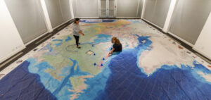 Floor Map in Nawapon, offering learners, faculty and visitors a unique opportunity to explore the rich histories, cultures, languages and lived experiences of Indigenous Peoples across Canada.
Presented by the Royal Canadian Geographical Society and Canadian Geographic Education, this impressive interactive map (akìzinàzowin) measures 11 metres by 8 metres (36′ x 26′), transforming the learning experience into a journey you can literally walk across. Participants are encouraged to step onto the map, move through regions, ask questions and discover Canada from an Indigenous perspective.
Unlike traditional maps defined by political borders, the Indigenous Peoples Atlas reveals the land through Indigenous language groups, communities, treaties, residential schools, reserves and other significant locations. It invites learners to see Canada in a new way while gaining a deeper understanding of the past, present and future of First Nations, Inuit and Métis Peoples.
Faculty are invited to book space to spend some time with the map.
Visitation is available from noon on Sept. 15 until noon on Sept. 25, 2026
Booking Instructions
- Click the link
- Select date and time
- Enter class name, contact name and email
- Include how many will be visiting the map in Nawapon
Faculty are encouraged to book class visits. The map comes with a comprehensive educational kit that includes a teacher’s guide, printed learning activities and supporting materials covering topics such as:
- Indigenous Governance
- Indigenous Languages
- Residential Schools
- Treaties, Land Disputes, Agreements and Rights
Don’t miss this unique opportunity to step into history, put your students on the map and navigate Indigenous learning. Faculty interested in bringing their classes are encouraged to book early to ensure access during this special two-week installation.
The timing of this installation is especially meaningful as it leads up to the National Day for Truth and Reconciliation on Sept. 30. The map provides an engaging and thoughtful way for classes to build their knowledge of Indigenous histories and contemporary realities while supporting ongoing learning and reconciliation efforts.
Tips for Interacting with the map
- The map is designed to be walked on, and participants don’t need to remove their shoes before stepping onto it.
- The map is intended to spark discussion and exploration, there’s no prescribed route or “right way” to experience it.
For more info, please visit this link.
- Posted in
- TRI News